
Faidhle:Papilio glaucus range map.JPG

Meud an ro-sheallaidh seo: 519 × 599 piogsail. Dùmhlachdan-breacaidh eile: 208 × 240 piogsail | 524 × 605 piogsail.
Am faidhle tùsail (524 × 605 pixel, meud an fhaidhle: 51 KB, seòrsa MIME: image/jpeg)
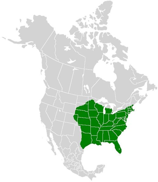
| Tuairisgeul | A range map showing the distribution of the Eastern Tiger Swallowtail (Papilio glaucus) |
| Ceann-là | (UTC) |
| Tùs | |
| Ùghdar |
|
| This is a retouched picture, which means that it has been digitally altered from its original version. Modifications: I added color to show the range of the Eastern Tiger Swallowtail. The original can be viewed here: North America second level political division 2.svg:
|
I, the copyright holder of this work, hereby publish it under the following license:
This file is licensed under the Creative Commons Attribution-Share Alike 2.5 Generic license.
- Faodaidh tu:
- a cho-roinneadh – lethbhreac a dhèanamh dhen obair, a sgaoileadh is a tar-chur
- ath-mheasgachadh – an obair atharrachadh
- Fo bhuaidh nan cumhaichean a leanas:
- urram – Feumaidh tu iomradh a thoirt air an ùghdar no an neach aig a bheil cead air, dìreach mar a thoill iad (ach chan ann air dòigh a chuireas an sùilean dhaoine gu bheil iad ag aontachadh riut no ri d’ obair).
- co-roinneadh co-ionnann – Ma dh’atharraicheas tu no ma leasaicheas tu an obair seo, ’s urrainn an tionndadh ùr fon cheadachas seo no fo cheadachas coltach ris.
Original upload log
This image is a derivative work of the following images:
- File:North_America_second_level_political_division_2.svg licensed with Cc-by-sa-2.5, Cc-by-sa-2.5
- 2007-12-08T23:23:36Z Lokal Profil 1712x1992 (335351 Bytes) Code cleanup
- 2007-10-07T07:55:13Z AlexCovarrubias 1712x1992 (350437 Bytes) == Summary == {{Information |Description=Map of North America and its second-level political divisions. Canadian provinces, US and Mexican states. Canada, Mexico, United States. |Source=Canada and US map by Alan Rockefeller.
Uploaded with derivativeFX
Eachdraidh an fhaidhle
Briog air ceann-là/àm gus am faidhle a shealltainn mar a nochd e aig an àm sin.
| Ceann-là/Àm | Dealbhag | Meud | Cleachdaiche | Beachd | |
|---|---|---|---|---|---|
| làithreach | 22:11, 20 dhen Fhaoilleach 2011 | | 524 × 605 (51 KB) | Meganmccarty | Removed range from Mexico and southern tip of Florida. Papilio glaucus is not found in these areas. P. alexiares replaces P. glaucus in Mexico. |
| 18:41, 31 dhen Dùbhlachd 2008 |  | 531 × 613 (26 KB) | Meganmccarty | {{Information |Description={{en|Map of North America and its second-level political divisions. Canadian provinces, US and Mexican states. Canada, Mexico, United States. Non-contiguous parts of a states/provinces are "grouped" together with the main area |
Cleachdadh an fhaidhle
Tha ceangal ris an fhaidhle seo san duilleag a leanas:
Cleachdadh fhaidhlichean uile-choitcheann
Tha na uicidhean eile a leanas a’ cleachdadh an fhaidhle seo
- Cleachdadh air arz.wikipedia.org
- Cleachdadh air bg.wikipedia.org
- Cleachdadh air ceb.wikipedia.org
- Cleachdadh air cy.wikipedia.org
- Cleachdadh air de.wikipedia.org
- Cleachdadh air en.wikipedia.org
- Cleachdadh air fr.wikipedia.org
- Cleachdadh air it.wikipedia.org
- Cleachdadh air ml.wikipedia.org
- Cleachdadh air nl.wikipedia.org
- Cleachdadh air ru.wikipedia.org
- Cleachdadh air sv.wikipedia.org
- Cleachdadh air vi.wikipedia.org
- Cleachdadh air war.wikipedia.org
- Cleachdadh air www.wikidata.org
- Cleachdadh air zh.wikipedia.org