
Faidhle:Knowledge of French EU map.svg

Size of this PNG preview of this SVG file: 585 × 599 piogsail. Dùmhlachdan-breacaidh eile: 234 × 240 piogsail | 468 × 480 piogsail | 749 × 768 piogsail | 999 × 1,024 piogsail | 1,999 × 2,048 piogsail | 1,212 × 1,242 piogsail.
Am faidhle tùsail (Faidhle SVG, a-rèir ainm 1,212 × 1,242 pixel, meud faidhle: 549 KB)
Gearr-chunntas
| Tuairisgeul |
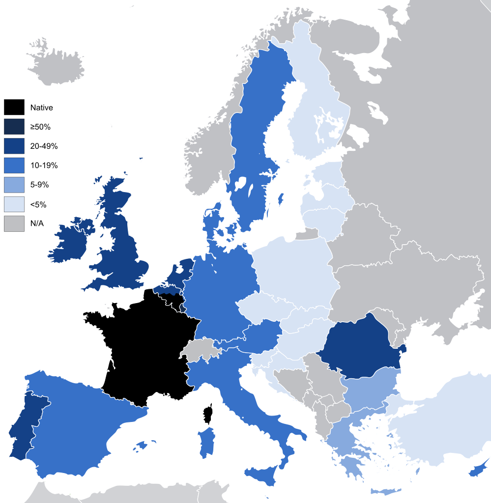
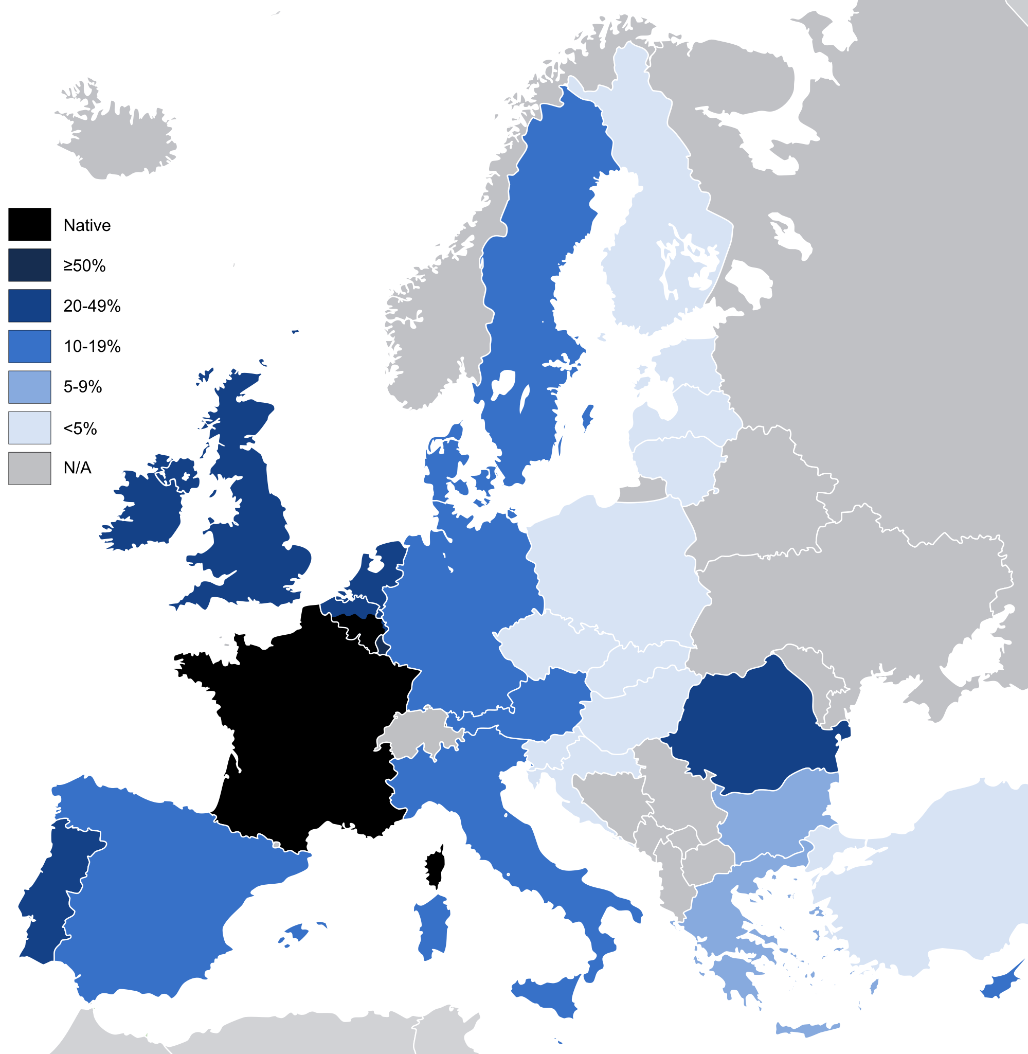
English: Knowledge French to a conversational level (other than as a mother tongue) in the European Union and the United Kingdom, according to: "Special Eurobarometer 243" of the European Commission with the title "Europeans and their Languages" [1]
|
| Ceann-là | |
| Tùs | Image:EU27-2008 European Union map.svg |
| Ùghdar | Addicted04 |
| Other versions |
|

Ceadachadh
| I, the copyright holder of this work, release this work into the public domain. This applies worldwide. In some countries this may not be legally possible; if so: I grant anyone the right to use this work for any purpose, without any conditions, unless such conditions are required by law. |
Eachdraidh an fhaidhle
Briog air ceann-là/àm gus am faidhle a shealltainn mar a nochd e aig an àm sin.
| Ceann-là/Àm | Dealbhag | Meud | Cleachdaiche | Beachd | |
|---|---|---|---|---|---|
| làithreach | 06:42, 14 dhen Ògmhios 2021 | | 1,212 × 1,242 (549 KB) | Sbb1413 | Reverted to version as of 02:02, 3 January 2012 (UTC) Reverting to include the knowledge of French in the UK, despite no longer being part of the EU. Rewording the filedesc. |
| 10:50, 3 dhen Ghearran 2020 |  | 1,212 × 1,242 (550 KB) | Darranc | Remove UK from EU | |
| 02:02, 3 dhen Fhaoilleach 2012 |  | 1,212 × 1,242 (549 KB) | Fenn-O-maniC | Added Wallonia | |
| 18:51, 6 dhen Mhàrt 2011 |  | 1,212 × 1,242 (546 KB) | Alphathon | Fixed Swedish lakes | |
| 18:43, 6 dhen Mhàrt 2011 |  | 1,212 × 1,242 (540 KB) | Alphathon | Added >5% category | |
| 20:45, 28 An Lùnastal 2010 |  | 1,212 × 1,242 (517 KB) | Alphathon | Key borders and Irish lakes added | |
| 14:15, 27 An Lùnastal 2010 |  | 1,212 × 1,242 (514 KB) | Alphathon | Cropped etc. for consistency with other, similar maps | |
| 18:27, 17 dhen Dàmhair 2009 |  | 680 × 520 (518 KB) | Addicted04 | map | |
| 16:09, 27 dhen t-Samhain 2008 |  | 1,218 × 1,245 (2 KB) | SammyV~commonswiki | {{Information |Description={{en|1=Knowledge French in the European Union, according to: "Special Eurobarometer 243" of the European Commission with the title "Europeans and their Languages" }} |Source=Own work by uploader |Author=SammyV |D |
Cleachdadh an fhaidhle
Tha ceangal ris an fhaidhle seo san duilleag a leanas:
Cleachdadh fhaidhlichean uile-choitcheann
Tha na uicidhean eile a leanas a’ cleachdadh an fhaidhle seo
- Cleachdadh air ar.wikipedia.org
- Cleachdadh air ast.wikipedia.org
- Cleachdadh air ba.wikipedia.org
- Cleachdadh air bg.wikipedia.org
- Cleachdadh air bs.wikipedia.org
- Cleachdadh air de.wikipedia.org
- Cleachdadh air el.wikipedia.org
- Cleachdadh air en.wikipedia.org
- Cleachdadh air eo.wikipedia.org
- Cleachdadh air es.wikipedia.org
- Cleachdadh air fa.wikipedia.org
- Cleachdadh air fi.wikipedia.org
- Cleachdadh air fr.wikipedia.org
- Cleachdadh air ga.wikipedia.org
- Cleachdadh air gl.wikipedia.org
- Cleachdadh air he.wikipedia.org
- Cleachdadh air hu.wikipedia.org
- Cleachdadh air id.wikipedia.org
- Cleachdadh air incubator.wikimedia.org
- Cleachdadh air is.wikipedia.org
- Cleachdadh air ja.wikipedia.org
- Cleachdadh air kbp.wikipedia.org
- Cleachdadh air kk.wikipedia.org
- Cleachdadh air kk.wikibooks.org
- Cleachdadh air lez.wikipedia.org
- Cleachdadh air lfn.wikipedia.org
- Cleachdadh air lmo.wikipedia.org
- Cleachdadh air nl.wikipedia.org
- Cleachdadh air olo.wikipedia.org
- Cleachdadh air pcd.wikipedia.org
- Cleachdadh air pfl.wikipedia.org
- Cleachdadh air pl.wikipedia.org
- Cleachdadh air pnb.wikipedia.org
- Cleachdadh air ro.wikipedia.org
- Cleachdadh air ru.wikipedia.org
Seall an corr dhen chleachdadh uile-choitcheann a nithear dhen fhaidhle seo.